McGinnis Glacier

 
Eating a sandwich after crossing the Delta River.

Eating a sandwich after crossing the Delta River.

I bought a pack raft at Beaver Sports in Fairbanks on a rainy weekend in early July and used it the next weekend to visit the Hayes Range across the Delta River. I’ve crossed the Delta River several times on foot in the winter while it was frozen, but the cold, swift water had kept me at bay during the summer.

On a Friday with perfect weather I parked alongside the Delta River across from McGinnis Creek. I started hiking upstream to get in position to float across, but one the river’s many braided channels pinched against the woods on the edge of the river plain, forcing me to inflate the raft earlier than I wanted. After floating across that channel, I hiked farther upstream with the raft on top of my head to a much broader channel that flowed past the mouth of McGinnis Creek. The water was very swift with some rough waves, probably Class II, but I barely caught a splash even though I left the spray deck at home.

I pulled into an eddy beside the gravel bar on the west side of the river and climbed out. Even though I could see the Richardson Highway just across the river plain, I already felt extremely isolated. I stopped to eat the sandwich I brought for lunch, then folded up the raft and stowed it in some bushes before starting up the creek. I had only walked a mile or so when I saw some animals moving up ahead. After ruling out moose and bear, I determined the two large brown objects were bison. They were at least another half-mile away, and as I continued toward them I saw another dozen or so at the edge of the foliage off to my right, including a couple of orange-yellow offspring. These bison migrate to the Delta River in the summer from their winter range off the Alaska Highway. When they saw me, they all stopped and watched me intently, then ran off into the brush as I got closer.

I continued along the creek as it curved into a valley, but after a mile or so the creek pinched against an impassable wall of rock. The current was raging, so I had no other option but to bushwhack through steep forest to get above tree line. I made it out of the woods after what seemed like an eternity, sweating and bleeding. Topping out on a small hill, I could see across a wide expanse of rolling tundra above the west side of the river, completely deserted except for a few moose roaming around. 

After surveying the landscape and consulting my map for some time I decided to shoot for a pass between two hills a few miles ahead that would minimize elevation changes and place me at a good spot to camp overlooking McGinnis Glacier. The peak of Mt. Moffit was situated directly over the pass from my vantage point, as if trying to hint where to go. I set off across the soggy tundra, and without any wind the insects were merciless.

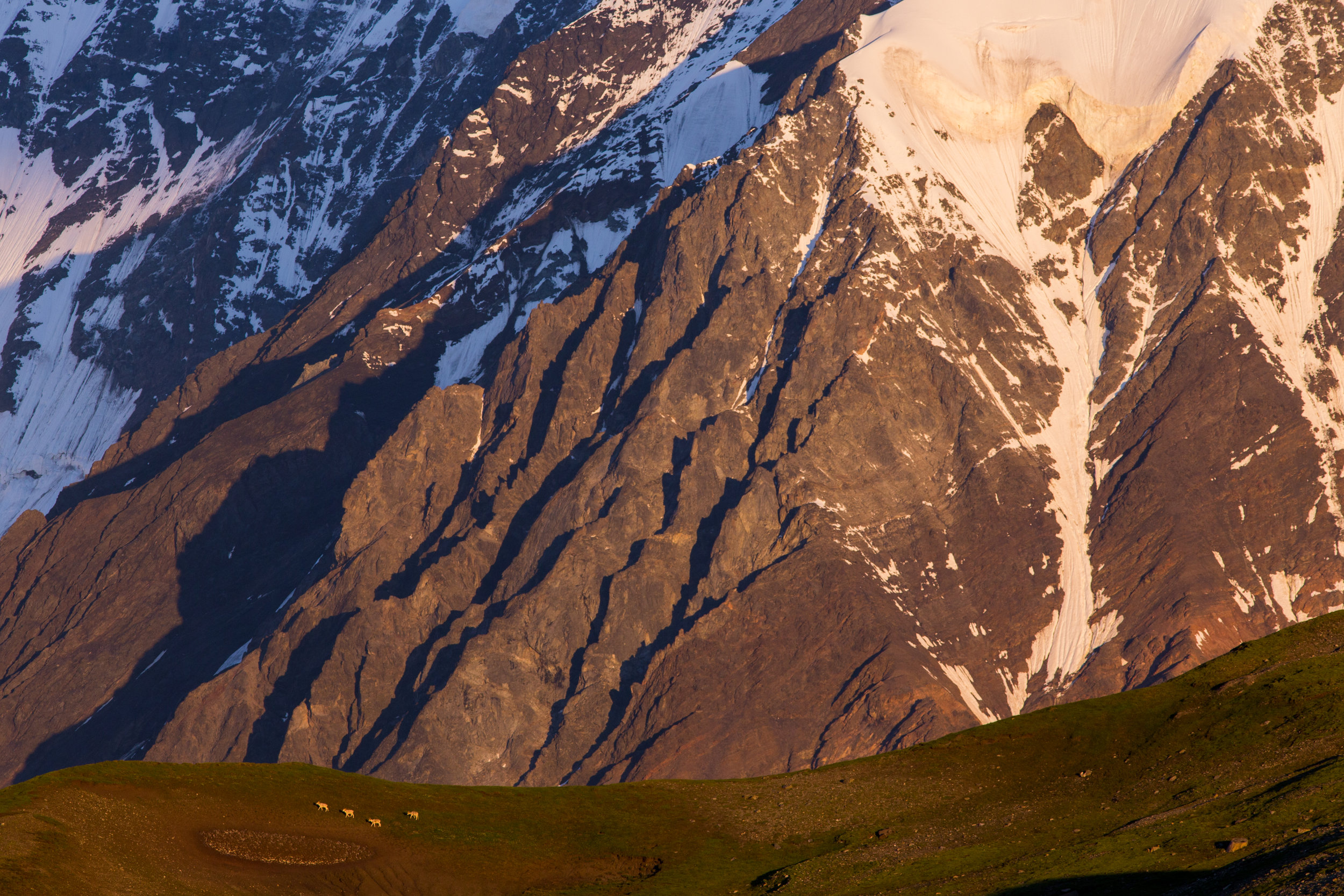
The sun was setting as I arrived at the pass. As I peeked over the other side, McGinnis Glacier suddenly came into view, sprawling over the valley floor below me. McGinnis Peak and Mt. Moffit were enshrouded in clouds, but I expected the clouds to clear later that night. I watched the light fade on Donnelly Dome and the Delta River as I set up my tent, then crawled in and set an alarm for 3:45 a.m. so I could catch the sunrise. I woke up to the sound of rain a couple hours later and glanced outside the tent to see everything enveloped in fog. I went back to sleep, a little less confident the clouds would clear.

When my alarm went off, I glanced out my tent to see Mt. Moffit glowing an insanely vibrant pink color. I immediately lost all sense of drowsiness and rushed out to start taking pictures. The clouds swirling around the tip of McGinnis Peak were on fire, and the snowy upper reaches of McGinnis Glacier glowed bright beneath craggy mountain ridges. As the light changed to an orange hue and started to illuminate the foothills below the tall peaks, I saw four Dall sheep rams emerge on the ridge across from me. They strolled across the ridge with the mountains and glacier in the background, one of those epic “only in Alaska” scenes that I get to experience now and then—the kind that seem like they are incredibly rare, but would probably feel much more common if I lived in a tent in the mountains and was awake every day at 4 a.m. After the sheep disappeared on the other side of the ridge, I crawled back in my tent and went back to sleep.

Dall Sheep crossing a slope at sunrise in the Hayes Range near McGinnis Glacier.

Dall Sheep crossing a slope at sunrise in the Hayes Range near McGinnis Glacier.

I woke up around 8 a.m. and stepped out of the tent. The landscape in front of me looked very similar to Denali National Park, except I was a lot closer to the giant 11,000'+ mountains you get to see from the bus in the park and there were no people anywhere nearby. I knew storm clouds would arrive later in the afternoon but I still had a few hours to explore, so I headed toward the ridge above McGinnis Glacier where I had seen the sheep earlier that morning.

I set my camera on my tripod at the top of the ridge and descended about 50 feet with my radio shutter release, intending to take a shot of the landscape with me in the frame. While waiting for clouds to stop blocking the light on Mt. Moffit, I noticed a Dall sheep ram staring at me on the slope to my left only a dozen yards away. I ran back up the ridge to get my camera, switched to my 300mm telephoto lens, then started walking back down the ridge only to see the ram had disappeared. As I reached the spot where I had first seen him, I suddenly spotted him standing farther down on the ridge looking up at me. Every other sheep I had ever encountered had quickly put ground between me and it, even if I wasn’t really that close. But this ram started slowly walking up the ridge toward me, and came close enough that I could hear him snort. He dropped onto the slope to my right as he passed me, stopping about 10 feet away and posing as if he wanted me to take his head shot. He continued slowly past me, but as soon as I turned my body to follow him with the camera, he panicked and started to run up the ridge. He froze suddenly when he saw my tripod and backpack at the top, then disappeared behind the ridge. I went back to taking landscape shots, spotting the ram ambling aimlessly along the ridge behind me a couple of times before he disappeared for good.

A curious Dall sheep ram.

A curious Dall sheep ram.

At that time, I saw what I thought was a huge eagle twisting in the air, but it turned out to be a fighter jet maneuvering in the sky, and, soon after, I heard its roar as it sped past through the valley. I did see an actual eagle flying over McGinnis Glacier a short time later, probably a golden eagle but too far away to tell.

As much as I wanted to stay another night, I knew I might get caught in a nasty mountain thunderstorm if I stuck around much longer, and the big mountains were likely to disappear soon, anyway. I started back to my campsite. The wind had started blowing hard and I found my tent had collapsed while I was away. I packed up and started hiking across the tundra, grateful for the wind as it kept the insects away. As I neared McGinnis Creek, dark clouds had already overtaken the mountains behind me and most of the land I had just crossed was covered in shadow. I started descending through the steep forest down to the creek, having to retrace my steps a few times to bypass cliffs while constantly yelling to scare off bears and moose. I emerged from the forest onto the creek bed and began following my footsteps back to the river.

Finally, I reached the edge of the Delta River and retrieved my pack raft. Golden light was shining on the river and the mountains on the far side. The river was heavily braided where I crossed, with some of the braids so shallow in places that my raft got stuck several times. I couldn't see my car when I reached the last braid, which made me worry I would have to walk a long distance to find it when I reached the far side, but as I started floating down the channel it quickly appeared around some brush just 100 feet away. I pulled my raft out of the water, shook the silt off, then deflated it and tossed it in the car. I had been gone for roughly 32 hours, but it felt like several days.

I’ll definitely be visiting the mountains and glaciers across the Delta River again next summer. There are several other adventures I’ve been considering for some time which suddenly seem much more attainable with a pack raft. I can't believe it took me this long to get one!


Black Rapids Glacier March 2016

Standing beneath an arch formation, Black Rapids Glacier.

Standing beneath an arch formation, Black Rapids Glacier.

I hiked to Black Rapids Glacier on a beautifully sunny day in March earlier this year. The expected high temperature was in the 30’s, but when I parked alongside the Delta River early in the morning, the temperature was only 3 °F and the sun was blocked by the mountains to the south. I carefully crossed the river ice and started moving quickly up the frozen creek leading to the glacier a few miles away, trying to stay warm.

The first 10 or 20 minutes of hiking were rather chilly until I reached direct sunlight. I stuck to the firm snow along the edge of the creek for a couple miles, then cut across the rocky plain directly toward the glacier as the creek took a detour to the right. After about an hour of hiking, I reached a boulder with a small rock cairn piled on top of it, and from there I could spy blue pieces of glacier ice up ahead. The creek curved back in front of me and I trod carefully across the ice on the final stretch to the glacier. 

I reached a small, couch-sized piece of glacier ice sitting alone in the middle of the creek and stopped beside it for a few minutes to rest. The mountains to my left were casting the valley in shade, and I quickly started to feel just as cold as when I started. With my fingers going numb, I continued up the creek as it began splitting and winding around large pieces of glacier ice separated from the main body of the glacier. 

Eventually, the creek narrowed and the rocky glacier moraine steepened on both sides of it. I would have liked to follow the creek to whatever giant hole in the glacier it must have emerged from, but I wasn’t sure how long of a detour that would have been and I had other sights to see. I climbed up the moraine on the right side of the creek, winding up rocky ridges until I could see a vast ice tongue below me a short distance ahead.  

I found a suitable spot to scramble down to the ice tongue and found myself standing in the sun again on a blindingly bright, white plain of snow-covered ice dotted with several large boulders. I took a break next to one of the boulders, using it to block the cold breeze while I basked in the sun. Eventually, I warmed up enough to break out the camera, which promptly chilled my fingers again. I put the camera away and started hiking around the bend in the valley where the glacier stretches for another dozen miles or so beneath giant mountains.

The snow on the glacier was only a few inches deep on the lower end of the ice tongue and there were several patches of exposed glacier ice. I had scouted my route very carefully beforehand and knew dangerous spots would be obvious. As I gently gained elevation, the snow became a little deeper and the patches of exposed glacier ice started to disappear. I strolled past a couple massive depressions in the snow where glacial streams disappear into the ice in the summer. One of them had a broken plastic marker on its edge placed by a research team. I spotted a massive ice cave where a stream flowing down a valley adjacent to the glacier had eaten away at the ice. I would have liked to explore it, but it was guarded by crevasses.

I didn’t have enough daylight to climb up one of the mountain ridges bordering the glacier, so I decided to climb up the western moraine and hope for a decent view of the main glacier valley.  To reach the moraine, I had to cross over a deep meltwater canyon separating it from the ice tongue—the canyon is clearly visible on Google Earth. In the summer, this would be a nearly impossible task since there would be a raging stream of freezing water flowing through the canyon with steep walls of smooth ice on either side.  In March, however, the canyon is half-filled with snow, and I was able to find a spot where the sides weren’t too steep and crossed over easily. I kicked steps into the snow to climb up the short, steep slope of the moraine.

Unfortunately, the moraine curved across the glacier and still blocked my view more than a mile or two up the valley, but I could now see 12,000+ foot tall Mt. Shand and other craggy peaks rising above the mountain ridges lining the north side of the glacier. I set up the tripod and took a bunch of pictures, then walked along the moraine to get a better look at the ice cave I spotted earlier while I ate the ham & turkey sandwich I packed for lunch.  

Mt. Shand and other craggy peaks of the Alaska Range tower over Black Rapids Glacier.

Mt. Shand and other craggy peaks of the Alaska Range tower over Black Rapids Glacier.

I packed up my gear and started heading back to the highway. Descending the steep slope of the moraine without any crampons or an ice axe was tricky as it was nearly 45 degrees and the snow was very firm, but sliding to the bottom would have been completely safe, if not enjoyable. I recrossed the meltwater canyon and traced my footsteps back down the glacier tongue. The temperature had finally climbed into the 30's and with sun on my back it almost felt like hiking in summer. I started following a much smaller meltwater canyon down the terminal moraine, figuring it would lead to some interesting features. I was rewarded when it brought me to the coolest ice cave I’ve ever seen, except for perhaps the long ice tunnel I’ve visited on Canwell Glacier a few times. 

The ice in the cave was ridiculously clear as it contained very little debris, and the striations usually present in similar caves (and glacier ice in general) seemed to be missing.  I could see daylight penetrating through the ice from above, which is very unusual for the caves I find in the Alaska Range because they typically have a layer of rocks or snow on top that blocks sunlight. There was actually a set of footprints in the dust covering the floor of the cave, but I couldn’t tell how old they were—I’d guess within the last year but probably not the last month. I followed them as the cave curved around and eventually terminated at another entrance flanked with medium-sized pieces of collapsed ice.  In the summer (when there would be water flowing inside) I suspect the cave is even more impressive and photogenic.

My footsteps in the thin layer of silt on the floor of the ice cave.

My footsteps in the thin layer of silt on the floor of the ice cave.

I emerged from the cave and quickly hopped off the moraine so I could move faster as the sun was already starting its descent behind the mountains. I stopped by a massive ice arch I had seen from a distance earlier, and the way it framed the mountains in the late afternoon sun was quite impressive. I put the camera away after leaving the arch and tried to avoid stopping for the rest of the hike as the sun was no longer helping me stay warm.

On these grueling day hikes, the return leg always feels twice as long as the forward journey. I could feel a blister or two developing on my feet and my legs were complaining with every step, but I pressed on, trying to reach the Delta River before dark. After the sun set, I watched the pink alpenglow fade on the mountains for an hour, with Mt. Silvertip glowing a full 20 minutes or so beyond the rest. Institute Peak shined like a ghost in the twilight several miles away, but then the mountains started growing dark. I could hear vehicles on the highway but I still had a mile or so to go. I slowly accepted that I would have to cross the river in the dark.

After what seemed like an eternity, I finally made it to the edge of the river. I pulled out my headlamp and flashlight and started to slowly retrace the same path I took earlier. With the flashlight pointed at the ice, I could easily see the bubbles and rocks frozen several inches below the surface. I no longer felt hesitant and crossed quickly to the other side, relieved that it wasn’t as frightening as I expected it would be. I wasted no time scrambling up the final slope between me and my car, and after 15+ miles of moderately strenuous hiking with 25-30 pounds on my back, my legs finally got to relax as I drove home beneath the aurora.  

For tips on photographing ice caves, read my post How to Photograph An Ice Cave.
Want to see Black Rapids Glacier? Check out my Black Rapids Tours winter offerings.