
The Buttress Range along the western edge of the Valley of 10,000 Smokes in Katmai National Park, viewed from the side of Baked Mountain.
When I stepped out of the bush plane and felt my foot sink into the ash and pumice, I instantly knew I was in a different place. It looked like a desert except for the blue glacier ice and waterfalls spilling down Mt. Mageik in the distance. And, unlike the desert, the breeze was cold. I was standing in the Valley of 10,000 Smokes in Katmai National Park, a land still recuperating from the devastating eruption of Novarupta in 1912. Some 25 or 30 miles away, tourists were crawling over each other trying to get shots of brown bears catching salmon. But I had this intriguing desolation all to myself, and I wouldn't see another human until my pilot returned to pick me up six days later.
After the plane took off, I began shuttling my gear to the nearby Baked Mountain Huts, a pair of huts located half-way up Baked Mountain in the heart of the valley. The huts were built in 1965 and occasionally serve as a camp for researchers, but they are available to the public for free on a first-come, first-serve basis. I passed several fragments of the huts on the side of Baked Mountain as I climbed up the slope (a sign of the intense weather frequently seen in the valley) and I sincerely hoped "blowing pumice" would not be in the forecast during my stay. I settled into the smaller of the two huts, which was a bit drafty and dark but much more comfortable than sleeping outside in the wind. With the huts as my base camp, I planned to visit the Mt. Katmai caldera and its impressive crater lake, and I also planned to spend time backpacking outside the valley on the other side of Katmai Pass where few people venture.

The smaller of the Baked Mountain Huts. Four beds, a table, storage space, and even electrical outlets if you happen to bring a generator.
The next day dawned sunny and warm, and I took my time soaking in the exotic landscape as I hiked to the base of the Knife Creek Glaciers with a heavy backpack. I followed a social trail most of the way from the huts to the saddle between Baked Mountain and Broken Mountain, where I gained a sweeping view of Novarupta and the colorful valley surrounding it. The slope to the valley floor below was steep, but I practically ran down it on the soft ash. As I circled the rim surrounding the lava dome of Novarupta, I spied steam escaping from some boulders at the dome's base and naturally had to investigate. The steam was warm and carried a pungent smell of sulfur, but I couldn't see the fissure beneath the rocks from which it emanated.
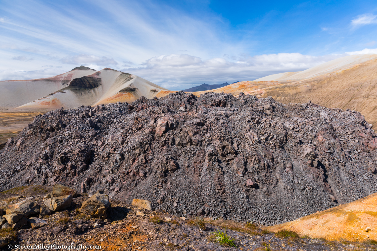
The lava dome plugging the Novarupta vent. Steam still wafts from various places on the dome.
I continued over rolling hills of pumice and ash. Deep cuts carved into the landscape by snowmelt presented annoying obstacles, but they paled in comparison to the gorges carved into the valley floor by the River Lethe and Knife Creek which I saw from overhead on my flight in. (Harrowing jumps over those gorges are typically the crux for people who hike into the valley from the Three Forks Overlook.) The vast emptiness was contradicted by ubiquitous human footprints, but there wasn't a person to be seen. Clouds draped the peaks of Mt. Katmai and Trident Volcano, which steadily grew larger as I approached. After one final hill, the Knife Creek Glaciers came into full view, sprawling over the valley floor in a jumbled, ash-covered mess.
The water discharging from the nearest glacier was filled with sediment, but there was snow hiding under wind-blown ash near its terminus. I scraped the ash off with my ice axe and scooped snow into my water bladder, which carried me through the next morning until I found clear running water higher up on the glacier. As the sun began to set, I pitched my tent in a quiet canyon near the foot of Whiskey Ridge with the glacier just a few dozen feet away. Incredible scenery with no people, no bears, no mosquitoes, and no wind...my kind of campsite!

The eastern summit of Trident Volcano rises above one of the Knife Creek Glaciers near sunset.
The next morning was overcast, but I thought the clouds swirling around the summits of Mt. Katmai and Trident Volcano would thin out later in the afternoon like they did the previous day, so I started following my planned route to the Mt. Katmai caldera. I’ve hiked over several rugged glacier moraines before, but the Knife Creek Glacier below Trident Volcano was on another level. Simply finding a place where I could start ascending the glacier was difficult, and I felt like a rat in a maze as I found my way around dead-ends and clawed my way over steep slopes of ice covered in loose ash. Eventually, I reached the bare ice beneath the eastern summit of Trident Volcano, where I found bright yellow-green olivine crystals sprinkled over the surface. When snow-filled crevasses began squeezing my path, I started following the ash-covered ice to my left, crossing a few hard-packed snowfields on my way to the pass between Mt. Katmai and Trident Volcano, which remained obscured by clouds.
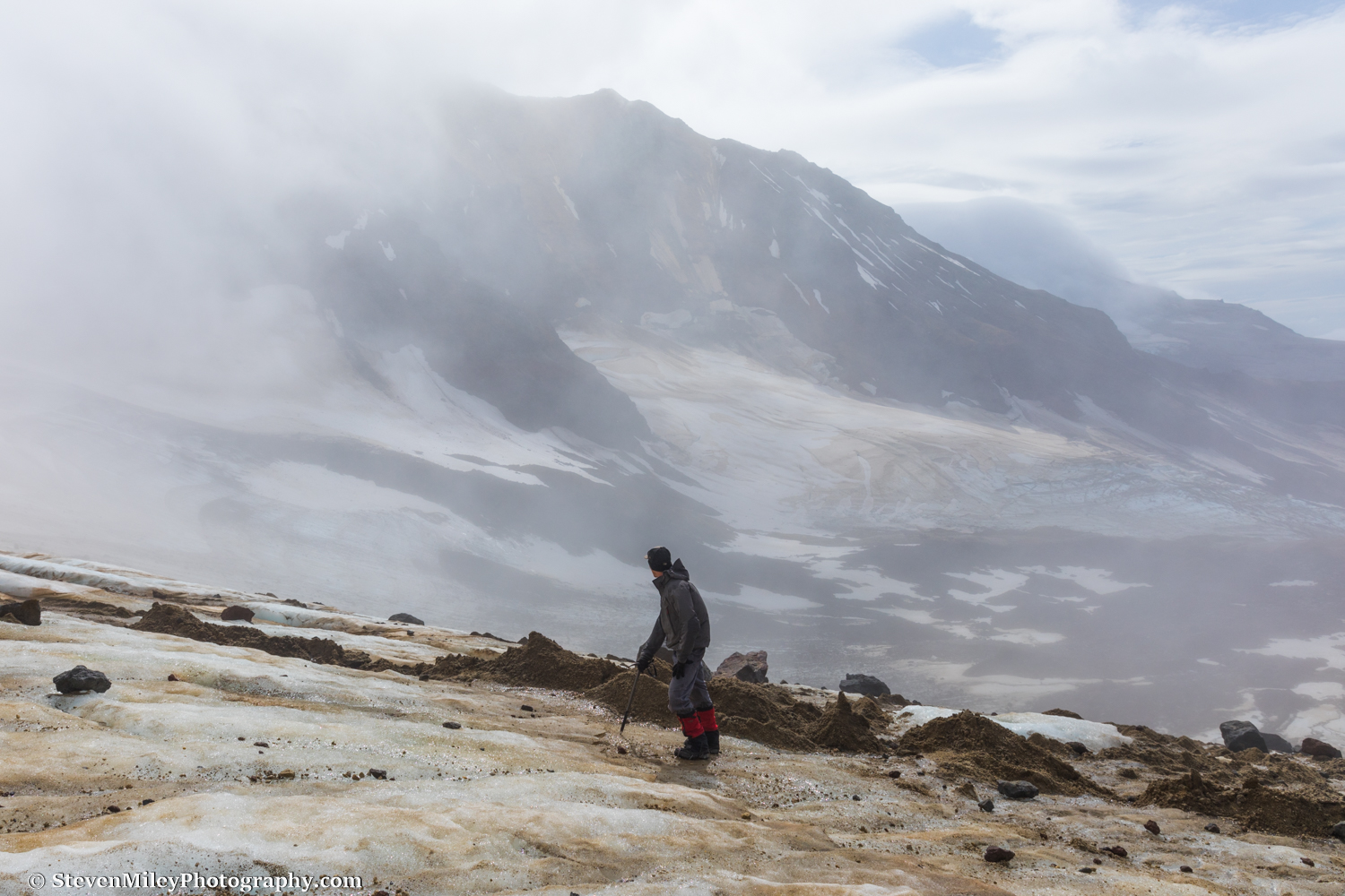
Ascending a steep section of ice between Trident Volcano and Mt. Katmai. The view is looking WSW toward East Trident.
After I entered the clouds, I couldn't see much more than a few hundred feet in any direction. I reached the pass and took a break to eat some cheese and chocolate chips. From there, I had hoped to have a good view of the ridge leading to the peak on the western rim of the Mt. Katmai caldera (elevation 6128') and climb it if it looked manageable, but even though the ridge was right in front of me I couldn't see it. I switched to my backup plan, which was to cross over the pass and hike up the gentle slopes on the south side of the caldera the next day if the weather improved. (The usual route people take to the caldera follows one of the other Knife Creek Glaciers, but that route features crevasse danger and it looked much less pleasant in early August in person than in pictures I had seen of it taken in early summer with more snow cover.)
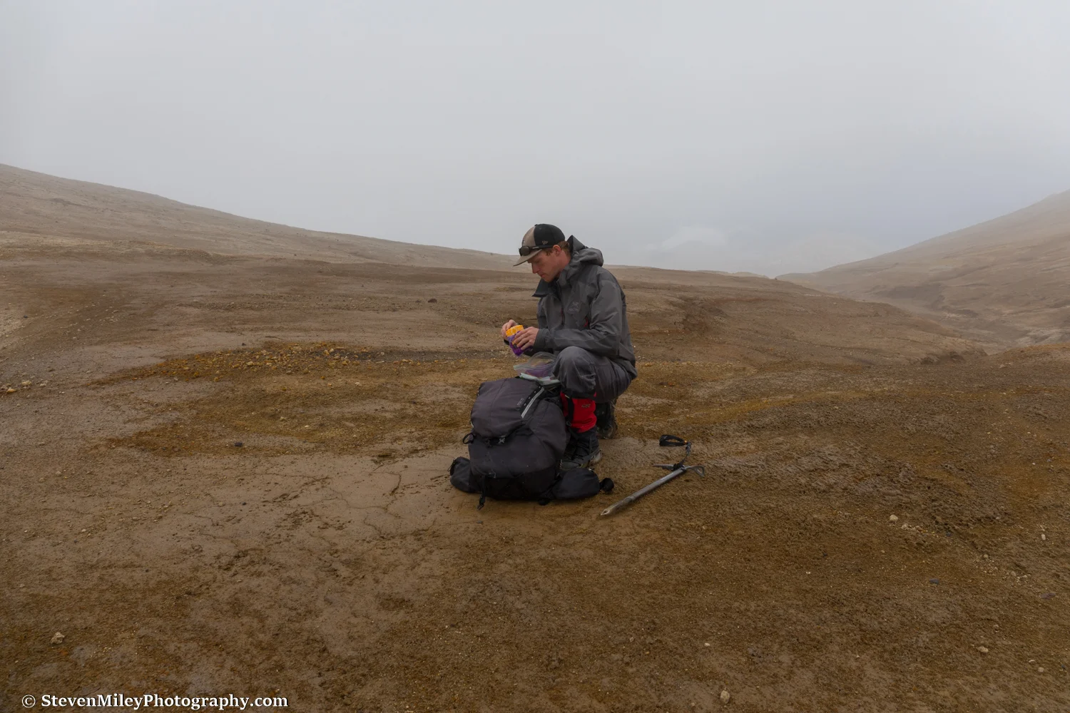
Pausing for some cheese at the pass between Trident Volcano and Mt. Katmai. The rounded top of Broken Mountain is barely discernible through the clouds to the right of my head.
I began descending from the pass down the Wishbone Glaciers (what's the with the plural names, Katmai?) and quickly realized visibility wasn't improving as I had expected it would. The glacier also turned out to be far less benign than I had hoped. Hard-packed snow still blanketed much of its surface, and even though I felt comfortable sticking to the edge of the snow near the ash-covered moraines, there were gaping crevasses (and I mean gaping) crisscrossing the glacier on my left that dissuaded me from drifting over the snow toward Mt. Katmai. Traveling along the gnarled moraines didn't seem perfectly safe, either, as some of the crevasses that extended into the moraines were partially covered by ash bridges, and several small ash "sinkholes" I passed made me worry that one might open up at any time beneath my feet. With no landmarks available for route-finding and no way to see problematic terrain in advance, my progress was incredibly slow, and I soon found sunset approaching with no idea when or if the glacier might mellow out below. I started working my way toward the western edge of the glacier, climbing over hill after hill and taking circuitous paths around nasty crevasse mazes.
Suddenly, a mountain slope emerged from the mist in front of me. It was the edge of Trident Volcano. I crossed to the bottom of the ash-covered slope and followed it along the edge of the glacier until I found a flat spot where I could place my tent. Looking up, I could just barely see a ridge topped with craggy volcanic rocks leading up into gray nothingness. Looking around, I noticed several of those rocks had toppled down the slope and landed near my chosen campsite, so I set up my tent behind the largest boulder and hoped it would block anything that might tumble downhill while I slept.
I awoke later that night to the steady pitter-patter of rain on my tent. I shifted in my sleeping bag and heard the sloshing of water at my feet, and when I looked I saw a small puddle forming on the floor of the tent. Great, my tent is leaking. My sleeping bag seemed dry enough (except for my toes), and since there wasn’t anything I could do about it, I went back to sleep.
When I rose in the morning it was still raining. I glanced outside the tent and the visibility had deteriorated even further. Drips of water were slowly but steadily falling from the roof of the tent and my sleeping bag was damp. I waited an hour or two to see if the weather showed any signs of clearing, but there was no change. I reluctantly gave up on climbing to the caldera and decided to traverse the south side of Trident Volcano to Katmai Pass, where I expected to find drier weather or at least better visibility in the Valley of 10,000 Smokes.
Hiking over the unfamiliar, extremely rugged terrain in poor visibility proved very laborious. I generally erred on the side of maintaining or increasing my elevation since I knew somewhere down below there were cliffs, creeks and glaciers that I wanted to avoid, and keeping the incline of the volcano to my right helped me stay pointed in the right direction. I still had to cross one narrow ash-covered glacier, which featured several steep hills of ash that I used my ice axe to help ascend. At one point, I stumbled into the fumarole field on the southern flank of Trident Volcano. I felt like I was walking on an alien moon as steam issued from yellow-green splotches on the ground all around me. I had read a paper before my visit that mentioned the volcanic gases in this area posed a potential danger to people, but the wind was blowing heavily so I didn’t think there would be any risk in continuing forward. I paid close attention for any signs of bodily distress, but I experienced no problems other than the overwhelming rotten-egg smell of sulfur forcing me to breathe through my mouth. Just in case the air was indeed toxic, I decided not to stop for a picture, which I regret because the scene was easily the most outlandish I've ever laid eyes upon. Oh, well—the image in my head will still haunt my dreams forever.

Moss grows beside a stream emerging from the lava flow on the southwest side of Trident Volcano.
I continued circling around Trident Volcano, anxious to find a landmark. After what seemed like hours of turning slightly right and wondering if one of the shadowy bear-sized boulders that kept appearing out of the mist might turn out to be an actual bear, I finally hit the lava flows on the southwest side of the volcano, which were deposited over the years 1953-1974. Hiking over the slippery, sharp volcanic rocks would have been slow and treacherous, so I was forced to detour miles around them and give up quite a bit of elevation. I soon began seeing caribou tracks, the first tracks of any kind I had seen for two days. Then I saw something really striking: green vegetation! A stream emanating from beneath one of the lava flows had given life to moss and shrubs that appeared neon green against the drab landscape enveloped by the gray backdrop. I thought the stream might be warm, but when I reached my hand in it was unpleasantly cold. I stepped over it and quickly encountered several more streams which flowed over vivid orange rock. The vegetation near the streams became heavy, and so did the bear tracks. I encountered fresh bear scat and began to shout as I walked to avoid a surprise encounter.
When I neared the base of Mt. Mageik, the clouds lifted just enough that I could see the way forward would require a couple stream crossings before opening into a wide plain between the bases of Mt. Mageik and Trident Volcano. Bear tracks and trails were everywhere. I crossed two swift, knee-high glacial streams, and I thought after that I was nearing Katmai Pass until I checked my GPS coordinates against my map—I still had three miles and 1000 feet of elevation gain left! And there were only two hours before dark! As I gained modest elevation walking over the plain, the clouds once again engulfed me and I began relying on my InReach to point me north since every direction looked the same. For a brief moment a skinny white object appeared about a half-mile away near the lava flows to my right, but the clouds quickly snatched it from view. Was it a person? A tent? A cabin? As much as I wanted it to be an opportune shelter, I assumed it was most likely a seismic monitor or some other scientific instrument, and I continued on without investigating it.
I crossed another sizable creek (perhaps the main branch of Mageik Creek) and followed it upstream into a valley where I began angling up the western side. When I reached an elevation equivalent to Katmai Pass, the clouds were still thick around me and the wind was blowing like crazy, and it was starting to get dark fast. My rain jacket had "wetted out" and my inner layers were damp, and I definitely couldn't rely on my drafty tent and soaking sleeping bag to keep me warm. Yet, dire as the situation may have seemed, I reasoned my worst case scenario was hiking all night in the dark to stay warm. It would at least get me to the peanut M&Ms I left at the Baked Mountain Huts sooner.
It grew dark to the point where I started using the screen of my InReach as a flashlight in between checking it to make sure I stayed heading north. The creek running in the valley below finally caught up to me and I crossed it, and I knew Katmai Pass was incredibly close. I could only tell I had crossed the pass after I noticed I had been walking at a slight downhill incline for a lengthy time, and, disappointingly, the weather showed no sign of improving. I started following a dried up stream bed knowing it could only lead downhill, and it eventually brought me to a miniature slot canyon carved into the ash and pumice. The canyon provided the shelter from the wind I needed, so I hopped inside and used the rain fly of my tent to protect me and my pack from the light drizzle. I managed to stay marginally warm and may have even caught an hour of sleep while I waited for sunrise.
When daylight returned, I peeked over the canyon wall and couldn't have been more delighted to see Baked Mountain straight ahead. The clouds had lifted! I realized I had taken shelter between Falling Mountain and Mt. Cerberus without knowing either mountain was beside me. The weather still looked awful over Katmai Pass behind me, and the wind was still blowing fiercely, but there was sunshine in the Valley of 10,000 Smokes and I started hiking toward it like a moth to a flame.

Drying out my sleeping bag and sweatshirt on the larger of the Baked Mountain Huts.
Back at the Baked Mountain Huts the sun was shining and the wind was blowing. I changed into dry clothes and hung my gear outside to dry. Completely exhausted, I relaxed at the huts for the rest of the day and read through a number of the logbook entries from the 1996 - 2006 era. (The most recent logbook volume apparently suffered water damage and was illegible.) A few entries detailed trips on the other side of Katmai Pass, and the descriptions of the terrain left me longing to go back from where I had just come—in better weather. I went to bed early that night before howling wind and rain arrived.

Caribou tracks and an odd patch of glacier ice near East Mageik Lake.
On my last full day in Katmai National Park, I set out to see the Mageik Lakes, a pair of lakes about a mile apart near the base of Mt. Mageik. I started descending Baked Mountain only to realize a few hundred feet down that I left my camera behind. My legs complained heavily as I climbed back up the slope to fetch my camera, and I knew I'd be crawling my way back to the huts later. I crossed the valley floor with the wind blowing in my face, watching the low clouds drift over the lakes in the distance and hoping the rain would hold off as I plodded past colorful extinct fumaroles. I walked beside the River Lethe for a stretch where it flowed even with the valley floor rather than in a deep canyon, and in that form it looked no more intimidating than any of the other glacial creeks I've waded across.
I made it to the edge of the eastern lake just as light drizzle began falling. A medium-sized waterfall and a couple smaller streams originating from glacier ice on the northern slopes of Mt. Mageik above fed the lake, and it discharged into a 10-foot deep canyon. I walked to the end of the canyon looking for a good crossing spot, but the rain intensified and started hammering the other lake, and I was forced to give up on seeing it and its more impressive waterfalls. The rain finally cleared as I slowly climbed up Baked Mountain back to the huts, and I was treated to one of the better sunsets I've seen this summer.
Perfect weather graced my final morning in Katmai. Heavy fog filled the lower valley, but in the other direction I could finally see the entirety of Mt. Mageik, whose upper half had remained concealed during my entire trip. The dark clouds swirling over Katmai Pass behind Mt. Cerberus were gone, and the jagged peaks along Mt. Katmai's crater rim were completely unobscured. The wind had completely disappeared. I was disappointed I wouldn't get to enjoy hiking on such a nice day, but at least I didn't have to worry about my pickup being delayed by bad weather.

Morning fog blankets the lower Valley of 10,000 Smokes.
I decided I was only making one trip to carry my gear down to the valley floor. I put everything that could survive a good tumble into my duffel bag, then rolled the bag and my tent down the side of Baked Mountain. I carried the rest of my gear down in my backpack and retrieved my duffel bag and tent near the bottom, then found a good landing spot for the plane and made a windsock with my ice axe and a roll of toilet paper. While I waited for the plane, I carried a wash cloth and a clean shirt to the River Lethe and tried to clean up as best I could before returning to society. The plane arrived right on time and I climbed in, sad to leave but anxious to get a hot meal in King Salmon.
I barely scratched the surface of the volcanic backcountry of Katmai National Park. It's the most unique place I've been in Alaska, and I can't wait to go back...with more food and a better tent!

The Baked Mountain Huts at sunset with Trident Volcano in the background.