My 10 Favorite Shots Of 2017


Narrowing down my favorite ten Alaska images of 2017 wasn't easy. I avoided the temptation to select what I thought were my ten "best" or "most impressive" images and instead focused on the ones that I enjoy viewing the most. As the photographer, they're more than just images to me—they're memories. So here they are, in no particular order, along with the memories they evoke. 

1. Root Glacier Ice Cave

IMG_1278.jpg

I found an ice cave beneath Root Glacier in Wrangell-St. Elias National Park a couple years ago. It's carved out by a stream from nearby Donoho Falls, and the cave entrance directly faces the sun in the evening during mid-summer. I returned to the cave this July for a shot of the sun shining golden light inside. I found a pair of sunglasses in front of the cave, which was awesome because I had just lost mine while pack rafting Jarvis Creek a week prior. Afterwards, I camped next to a cool group of people who shared their salmon spaghetti with me. For tips on photographing ice caves, see my tutorial here.


2. Denali Winter Sunrise

KI6A5013.jpg

Great summer shots of Denali are ubiquitous, but there are far fewer great winter shots of the mountain and even fewer that contain a real adventure aspect. I spent a cold night (-20 °F) camped out on a ridge in Denali National Park for this shot, where I also saw a great aurora show and had a close-up sheep encounter. Read more about my winter excursion to Denali National Park here.


3. Valley of Ten Thousand Smokes

_L5A0333.jpg

I thought I stumbled onto a putting green when I found this solitary patch of green in the otherwise barren Valley of Ten Thousand Smokes in Katmai National Park. The terrain is incredibly rugged and very alien and I think this picture captures that best out of all the photos I took. Read more about my trip to Katmai here.


4. Gerstle River Bridge Aurora

_L5A3700.jpg

This November was the first time in a very long time that I caught an impressive aurora display along the Alaska Highway. I wanted to nail a shot of the Gerstle River bridge or the Johnson River bridge for some time but the aurora just never cooperated until I got this shot. I could have taken an even better picture if I had been on the other end of the bridge when this happened. For tips on shooting the aurora, see my Aurora Photography Guide. I also offer Aurora Borealis Photography Tours.


5. Portage Lake Whiteout

KI6A2482.jpg

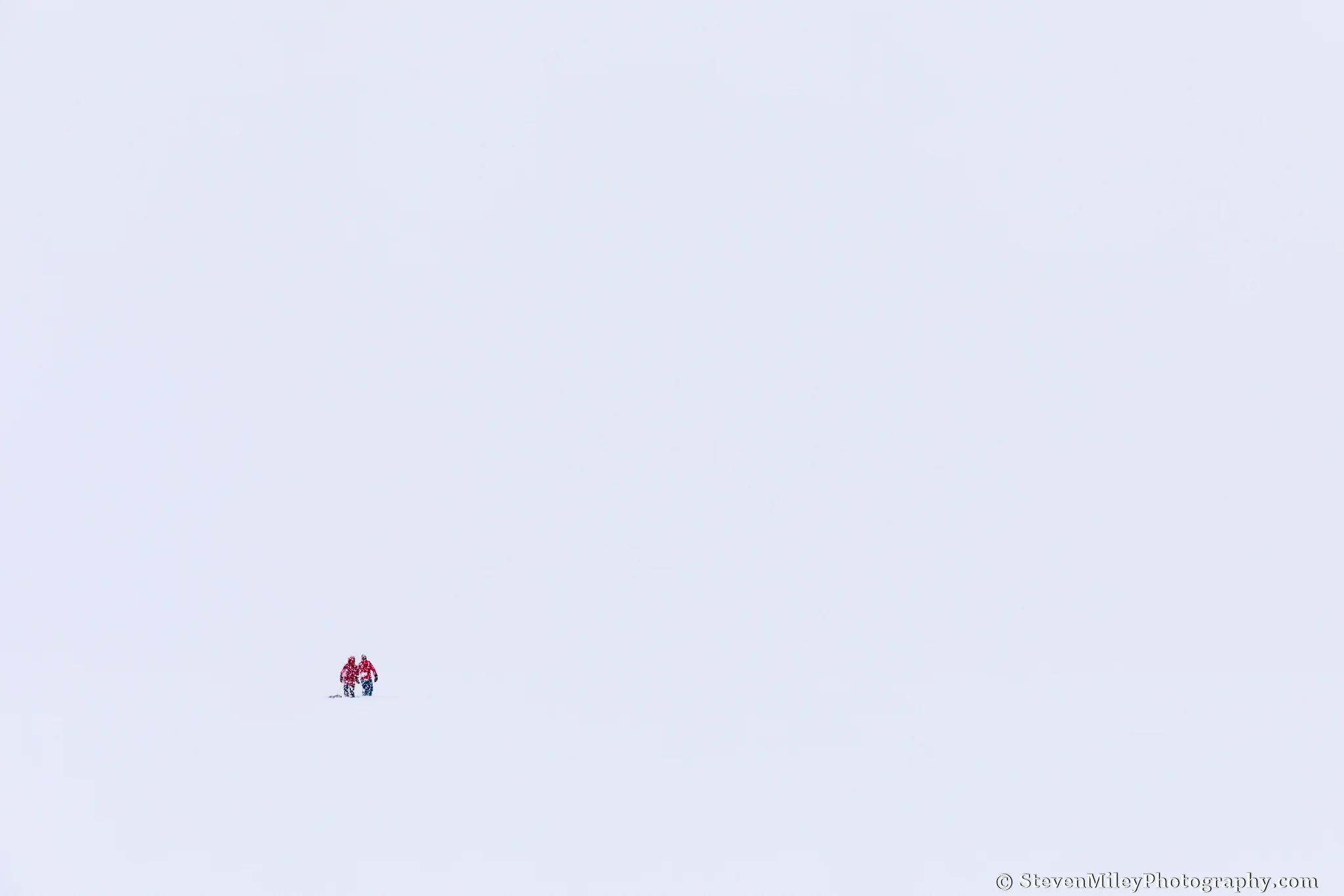
I skied across Portage Lake to Portage Glacier during incredibly heavy snowfall in January. There were several other people visiting the glacier that day and they appeared like dots on an otherwise uniform background of white. I like this shot because the viewer is free to imagine the context surrounding the two people. Even though I know they were OK, it appears to me like they are lost wandering through a blizzard in the middle of nowhere. 


6. Castner Glacier

KI6A2509.jpg

I like this shot because the glacier looks jagged and uneven yet I'm casually walking around on it without the usual ice climbing gear or outerwear you see in similar shots. It also reminds me of having the entirety of Castner Glacier to myself in perfect summer weather. Read more about my summer trip to the Thayer Hut and the upper Castner Glacier here.


7. Pioneer Ridge

_L5A2216.jpg

This shot of Denali's Pioneer Ridge at sunset takes me back to the high point of my trip to Peters Glacier. After a miserable night of constant rain and temperatures barely above freezing, I had a full day of warm sunshine, topped off with a great sunset while standing closer to Denali than almost anyone ever ventures on foot. I enjoy pictures of striking mountain ridges, and Pioneer Ridge is probably the most photogenic of Denali's many ridges. Read more about my trek to Peters Glacier and the base of Denali here


8. Blue Heart Of Root Glacier

IMG_1789.jpg

I was looking for interesting ice formations on Root Glacier when I came across this blue pool that looked like a heart from a certain perspective. It lined up perfectly with the mountains in the background and the lighting and cloud cover were just right. Hiking over glaciers in the summer is one of my favorite things to do in Alaska, mainly because of views like this.


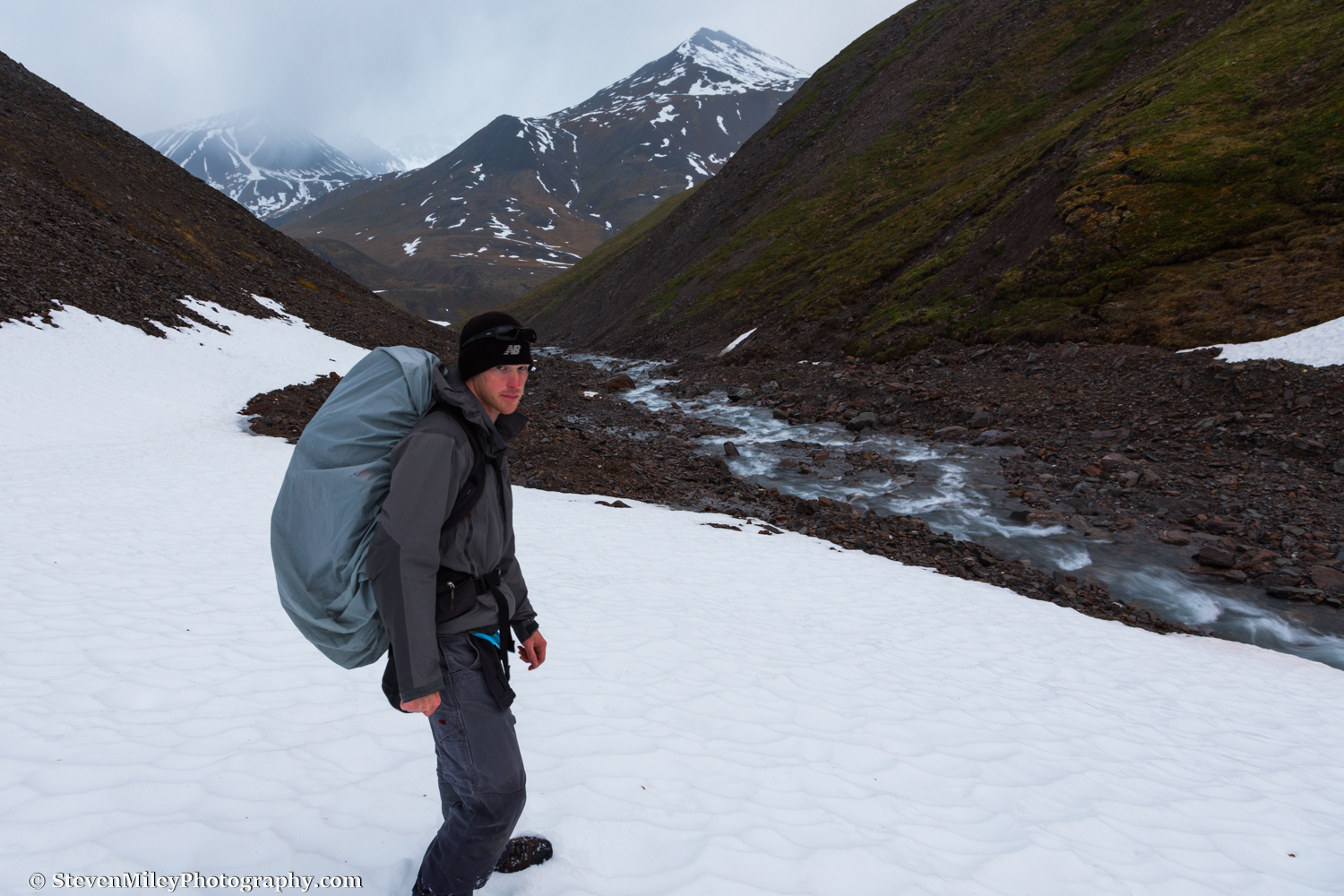
9. Brooks Range Antler Sheds

KI6A2914-HDR.jpg

This is the only time I've found a matching pair of shed caribou antlers. I took this some time after midnight in the Brooks Range at the top of a pass after a brief heavy rain, and it was almost like the antlers were the reward for reaching the top. I also think the shot captures the dynamic and wild nature of the Brooks Range. Read more about my hike in the Brooks Range under the midnight sun here.


10. Augustana Glacier Cave

KI6A2919-HDR.jpg

My adventure buddy Forrest and I skied 7 miles to the base of Augustana Glacier in February. I originally planned to take aurora shots from a neighboring ridge, but the aurora was a dud that night and we spent our time exploring several cool ice caves instead. This cave had a very majestic opening and the blue color of the ice mixed well with the reflection of sunrise colors off the nearby mountaintops and sky. No doubt this cave looks entirely different now after the summer melting season. Read more about my Augustana Glacier adventure here.


A Polar Day Hike In The Brooks Range


The term midnight sun refers to the polar phenomenon where the sun doesn't fully set below the horizon on and around the summer solstice. However, "midnight sun" is often informally used when describing the long daylight hours and twilit nights experienced by areas of Alaska where true midnight sun does not actually occur, which includes most of Alaska's population centers and major tourist destinations. That's why I prefer the less ambiguous term polar day when referring to the 24/7 daylight experienced by the Arctic. 

Hiking only during traditional waking hours is a sad waste of polar day. This goes double for photographers since the light is better when the sun is flirting with the horizon. So, on an excursion above the Arctic Circle following the recent summer solstice, I decided to go for a day hike in Alaska's Brooks Range at 'night'. I started my hike shortly before 9 p.m., ascending through a valley immediately west of the Dalton Highway just south of Atigun Pass. A clear-running creek flowed through the valley, fed by dozens of smaller streams cascading down the surrounding mountains. 

9:58 P.M. - A mile or two west of the Dalton Highway.

9:58 P.M. - A mile or two west of the Dalton Highway.

I had traveled only a short distance when I saw footprints in the creek bed. They appeared to be less than a day old and left by a single person. Without the footprints, it would have been tough to tell anyone had ever been there: there was no social trail, no litter, no cairns, and no fire pits—not that there was any wood to burn in the treeless tundra.   

After a few miles of easy hiking, I reached the base of a pass. At that moment, the clouds lowered over the mountain peaks around me and steady rain began falling. I tightened the hood of my rain jacket and began ascending the steep scree slope. After the slope lessened, the rain trailed off and the sky began to clear. The peaks of the mountains reemerged from the clouds with a dusting of fresh snow. The clock had struck midnight already and the clouds were beginning to glow with sunset hues, while the sun itself had disappeared behind the mountain on my right.

12:17 A.M. - Stopping for rest at a small pond on the way over the pass.

12:17 A.M. - Stopping for rest at a small pond on the way over the pass.

On top of the pass, I encountered a matching pair of shed caribou antlers. I passed several more sheds conspicuously laying on the open tundra during my trek. Despite all the sheds, I failed to spot any caribou. In fact, rather surprisingly, birds were the only wildlife I encountered.

12:59 A.M. - Caribou antlers at the high point of the pass.

12:59 A.M. - Caribou antlers at the high point of the pass.

A creek flowed down the other side of the pass, but it dropped over a small waterfall into a short ravine lined by cliffs, so I was forced to cross several snow slopes where I sunk to my thighs in snow before I was able to gain the rocky creek bed. I found part of a Dall sheep jaw next to the creek, along with Dall sheep tracks and wolf tracks. I also found the tracks of the mystery hiker again.

1:33 A.M. - Hiking down from the pass over lingering snow patches. (That's my "I love Alaska" face.)

1:33 A.M. - Hiking down from the pass over lingering snow patches. (That's my "I love Alaska" face.)

I crossed the creek before it flowed into the west fork of the Atigun River, then started following the river valley as it gently curved northeast back to the highway. The classic U-shape of the valley indicated a massive glacier once flowed through it, but there was no glacier left to be seen. The true midnight sun peeked through a thin gap in the clouds, painting the mountains behind me with shifting patches of alpenglow. As I approached the edge of the river, I was astounded by the vivid blue color of the lingering aufeis—sheet-like ice formations partially covering the river formed by the repeated flowing and freezing of groundwater during the winter. A caribou antler laying near a 7-foot thick slab of ice begged for a photograph.

2:54 A.M. - Caribou antler beside the (officially unnamed) west fork of the Atigun River. Aufeis still partially covered the river in places.

2:54 A.M. - Caribou antler beside the (officially unnamed) west fork of the Atigun River. Aufeis still partially covered the river in places.

As I plodded along the tundra, I began seeing heavy signs of bear: a few bear tracks along vague game trails, ubiquitous scat (they had been eating plenty of grass), and a clump of golden-brown fur. I kept my eyes open for bears and other wildlife, but the animals had seemingly vanished, perhaps into the countless side valleys I passed. Each side valley was worthy of its own day hike, with many of them containing roaring waterfalls and easy ridges leading to higher elevations. I kept hoping for the clouds to part, but the best I got was a few glimpses of 3 a.m. blue sky.

3:54 A.M. - One of the many side valleys.

3:54 A.M. - One of the many side valleys.

Later, as I steadily approached a bend in the valley, I saw a curious display. A bright beam of sunshine would light up part of the tundra like a golden spotlight for a few minutes, then the light would disappear for a few minutes until another ray burst through the clouds. It continued cycling like this for over an hour, almost like a light switch was being thrown on and off. Eventually, the switch turned off for good and the light on the rest of my hike was rather unspectacular.

5:14 A.M. - Spotlight on the tundra. 

5:14 A.M. - Spotlight on the tundra. 

As I crested a small rise where the valley finally curved toward the highway, I spotted an orange tent gleaming in the sun about a mile away. It was the mystery hiker. I didn't disturb whoever it was, but I wonder if they saw my footprints later in the day and puzzled over them like I did theirs. 

6:17 A.M. - Recent footprint along the edge of a tundra stream left by another hiker.

6:17 A.M. - Recent footprint along the edge of a tundra stream left by another hiker.

I started to run out of gas with a few miles to go. With the pipeline in sight and the weather slowly trending toward rain, I forced myself to keep going, rather than pitch the tent I had brought in case I encountered foul weather. I arrived at the Atigun River shortly before noon, too tired to bother finding a spot where I might cross without getting my feet wet. Unlike many of the rivers I've crossed in Alaska, I could see beyond its surface and didn't have to guess if the water would stop at my shins or above my waist. I crossed two channels that were both top-of-the-knee deep, then trudged in wet boots the final span to the highway, ending about 19 miles from the start of my route and 13 highway miles from my car on the other side of Atigun Pass.   

I planned to hitchhike back to my car, or else start walking back with my thumb extended if no one picked me up after several hours. The first vehicle I saw heading south passed me by. I waited another half-hour for the next vehicle, a semi-truck that stopped to pick me up. The driver told me along the way that he always wanted to check out the valley I had just hiked through, and that he had been seeing a large number of grizzlies above the pass this year. He dropped me off at my car and I drove until I found a quiet road pullout, where I slept until midnight. 

Although Alaska's summer tourism season is just beginning to reach full swing around the summer solstice, the solstice also marks the beginning of decreasing daylight hours south of the Arctic Circle, a reminder to residents that another long, dark, brutally cold winter is on its way. It's comforting knowing that polar day will last another few weeks in the Brooks Range and that, if I feel the need to get my lost daylight back, I can just drive north.