Packrafting the McKinley River with nonstop views of Denali.
Last June on a three-night backpacking & packrafting trip in Denali National Park, I crossed the surging Muldrow Glacier and floated the McKinley River to Wonder Lake with my adventure buddy Ryan. You could call our route the “Eielson Visitor Center to Wonder Lake Traverse”. I’m not sure if it’s ever been done before, but certainly no one had done it since Muldrow Glacier began surging the preceding winter, so I was quite excited to take some novel shots of Denali along the way.
When we arrived at the park, seemingly every ranger had heard about our planned route. They repeatedly warned us that the glacier was surging and there had been glacial lake outburst flooding along the McKinley River. “The river rose 3 feet in an hour,” more than one person told us. But they were also enthusiastic about our trip and keen to hear about our experience crossing the glacier since the former optimal crossing spot had been wiped out by the glacier’s recent advance and was now a hopeless maze of cracked up ice. Several tourists who noticed the paddles sticking out of our packs questioned us as we lugged our gear around the bus depot and the Eielson Visitor Center. I often forget most people outside of Alaska have never seen a packraft before.

Thorofare River.
Light rain fell as we descended the Gorge Creek Trail, but it quit by the time we reached the bottom. We waded the ice-cold water of Gorge Creek with bare feet, then hiked west across the Thorofare River plain as the sun emerged and a rainbow appeared behind us. We we were able to jump the numerous braids of the Thorofare River without removing our hiking shoes, albeit just barely with our heavy packs on. As we approached Glacier Creek with Muldrow Glacier in view on the opposite side, we spotted two people climbing up the steep, brushy edge of the glacier. They seemed to vanish after we lost sight of them in the brush halfway up. I assumed they found the slope too steep or the bushwhacking too difficult and probably set up camp in some trees around the corner, since we didn’t find them on top of the glacier. Ryan was never totally convinced they weren’t bears, but I clearly saw two human figures, one of which had a bright red jacket or pack cover. They were the last people we would see on our trip.
We rock-hopped across Glacier Creek and scrambled up the edge of Muldrow Glacier. On its eastern edge, the glacier ice is covered in rock and vegetation, and you could hike for a mile across it without realizing there was ice just a foot or two beneath the surface. As we reached a high point on this “dead ice” portion of the glacier, we spotted Denali emerging from behind the clouds for the first time, and we could see part of the new surging wall of ice creeping down the glacier. Upstream of the advancing wall of ice, the glacier was a churned-up mess, completely unrecognizable from the last two times I hiked on the glacier.

Denali emerging from clouds viewed from the dead-ice moraine of Muldrow Glacier. The surging face of the glacier is visible between the mountains and the moraine in the left half of the image.
As the evening light turned golden, we approached the imposing wall of surging ice. Massive chunks of ice tumbling down the face reverberated like thunder. Where the new surging ice pinched against the old dead ice there was an ice-dammed lake with a roaring waterfall emptying from it into another lake below, which drained under the surface of the glacier somewhere unseen. These ice-dammed lakes form repeatedly as the surging glacier cuts off the flow of water, and when the ice restricting them eventually melts away or breaks loose it can cause flooding downstream. The surging ice had also consumed an old meltwater canyon that used to run for miles down the glacier and constituted the major impediment to crossing the glacier lower down on its length. With that canyon eliminated and a significant amount of the meltwater that once flowed through it apparently rerouted, the vast lake on the far edge of the glacier into which the canyon stream formerly emptied had nearly dried up. I was hopeful we wouldn’t need the packrafts to cross that area.

A small pool in front of the surging face of Muldrow Glacier, taken around midnight. This spot may be buried in ice by now.

Grizzly tracks in the mud.
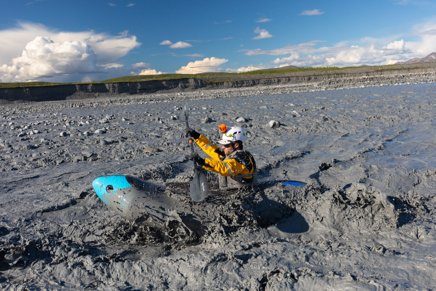
We camped near the face of the surging ice on a soft bed of dry silt littered with caribou tracks. In the morning, we packed up and traced the edge of the face until pooling water and waterlogged silt with the consistency of quicksand forced us to seek drier ground. There was a single meltwater stream flowing on the edge of the glacier we needed to cross, but when we tried to take a direct route to this stream we found ourselves crossing shallow crevasses plugged with dirt and rock, and a gaping moulin in the mudflats to our left convinced me it would be safer to stick to the high ground where the glacier ice was covered in solid rock rather than take a shortcut across the mud where the lake had been a year prior. Imagine walking through mud deposited on top of ice but having no idea how deep the mud is or how far you might sink in it, and nearby there’s a hole leading straight to oblivion! This is why few people cross Muldrow Glacier.
We circled around to the edge of the stream and found some medium-sized grizzly tracks where a bear had crossed and wandered down the glacier. The stream was flowing quickly as most glacier streams do, and it was very silty and completely opaque so judging its depth was difficult. I thought it looked crossable on foot but it emptied into a calm lake full of muddy icebergs a short distance downstream, which we could easily cross in our packrafts. I dropped my pack and started crossing the stream to test the depth, and when the water approached my waist we decided to blow up the rafts instead. I think the stream was crossable, but when you’re carrying thousands of dollars in camera gear in your pack there’s no sense taking unnecessary risks.
It took 15 minutes to blow up the rafts and secure our gear, about one minute to actually paddle across the water, and another 15 minutes to deflate the rafts and repack. But we were now safely on the far side of Muldrow Glacier with a straightforward 1000-foot climb ahead of us. Caribou tracks crisscrossed the surrounding scree slopes, and I spotted a few in a streambed below as we ascended a ridge toward an alpine saddle.

Ryan ascends a ridge with Muldrow Glacier in the background.
We dropped our packs when we reached the saddle and basked in the warmth of the afternoon sun. With a cushioned flat spot to pitch a tent, a clear line of sight to Denali, and a cool rocky ridge to shoot photos from nearby, the saddle was a perfect place to camp, so we called an early end to hiking for the day. After a short rest, I wandered over the hillside in a pair of socks to find water while my shoes dried in the sun. Caribou and grizzly tracks were everywhere, but I didn’t see any human footprints. I surveyed the steep scree slopes below the rocky ridge above and realized they would be a bit more challenging to ascend than I hoped, but manageable.
I returned to camp as clouds began drifting over the saddle and threatening rain. My hope for Denali sunset shots faded, so I fell asleep early and set my alarm to check the conditions at sunrise. I poked my head out of the tent at 3:30a.m. and Denali was still shrouded in clouds, so I went back to sleep and hoped the mountain would clear up by 10a.m. when the sun angle would be pleasing for some non-golden hour shots.
After we rose in the morning Denali was starting to emerge from behind the clouds. We began hiking uphill to a ridge pointing toward Denali, crossing over a steep section of slushy snow to bypass rock outcroppings. On top of the ridge we found colorful scree and even steeper slopes on the other side. Ryan climbed up a rock to pose in front of Denali for scale.

View of Denali from the hills above Pirate Creek.
On the way back to camp, we spotted two grizzlies in the brush below, perhaps a half-mile away. We kept an eye on them as they ambled along a small creek. After we reached camp, we watched one of the bears begin scaling the slope to the end of the ridge we had just climbed. Perhaps we should have continued along the ridge and I might have taken some lucky shots of Denali with a grizzly in the foreground, but I’ll just have to try again someday.
Sidehilling over steep snow. The tracks crisscrossing the ridge to the left belong to caribou and bear.
By the time we packed up rain clouds were drifting over the Thorofare River, though the sun was still shining on the saddle. We started moving to avoid getting caught in a possible thunderstorm while at high elevation. From up high, we could clearly see how the surging ice of Muldrow Glacier was swallowing the land and old glacier ice in front of it. We navigated over a hilltop and back down across glorious hard tundra, then descended from the hillside to the McKinley River Bar through a maze of dense brush. After struggling through alders for a short but painful stretch, we emerged onto the broad plain beside the McKinley River, and the hiking became easy once again. Fresh silt on the gravel bars clearly marked the high water line from a recent flooding event, and it was at least a few feet higher than where the water was currently sitting.
Rain falls over the Thorofare River as we hike over hard tundra toward the McKinley River. Muldrow Glacier is in the valley below.
With plenty of time to kill, Ryan strolled down the river to scout rapids, while I pitched the tent in case the rain drew closer. Dry mud on the river bar offered a comfy spot to place the tent, and as soon as I nestled inside the sun began breaking through the clouds. I could see the sun shining on the river several miles downstream and looked forward to a sunny float with views of Denali.

McKinley River Bar.
Ryan returned excited about a rapid he wanted to hit and we had lunch before hauling our gear to the edge of the river. I suppose technically the McKinley River counts as whitewater, but it more closely resembles flowing chocolate milk. I’ve never seen another creek or river in Alaska so dark and opaque. I don’t recall the river being so thick with silt the first time I floated in in 2017, so perhaps it was due to the glacier surging. Ryan ran a short section of Class III rapids while I photographed, and we quickly learned the silt in the river stuck to everything. (Rafts, clothes, faces…everything.) I packed my camera gear into dry bags and stuffed them inside the cargo compartment of Ryan’s raft, then blew up my raft. I didn’t have a dry suit or a skirt for my raft, so I skipped the rapids and put in downstream.
Ryan hits a rapid in the McKinley River.
The river wasn’t without a few surprise borderline Class II/III rapids, however, and I nearly fell out of my raft in one spot. But I could have just as easily fallen out on flat water while gawking at Denali and the Alaska Range glowing in the evening sunshine as I floated downstream. Every time I raft on a swift, icy river like the McKinley, I feel scared until the first time I get stuck in a shallow channel. Then the reality of paddling on a braided glacial Alaska river sets in, and I find myself spending as much time dragging my raft back into deeper water as I do paddling. When we weren’t stuck, the current carried us along at 10 miles per hour or faster, so the 9 miles we floated didn’t take very long. Before we exited the river for good near the McKinley Bar Trail, I took a quick shot of Ryan floating in front of Denali, a shot I had wanted to take for a few years and the impetus for the whole trip.
The mosquitoes on the river bar were merciless, so we cut our celebration short and beelined for the McKinley Bar Trail. We picked up the trail and labored a couple more miles through forest and bogs with the setting sun playing peekaboo through the trees in front of us and Denali looming over the trees behind us. We camped at the trailhead that night and caught the early bus out of the park the next morning, still covered in silt.
The park road was shut down later that summer at Mile 43 and will be shut down again throughout this summer season and maybe next, and bus service into the park was hampered the previous summer by the pandemic, so I’m lucky this trip happened at all. I don’t think I’ll make it this far into Denali National Park again anytime soon, but after this trip I’ve been dying to revisit Peters Glacier and spend more time there, especially with my new, better camera equipment. This was still a nice sendoff for my old Canon 5D Mark IV and my Canon 24-70mm f/4L.

Taking out from the McKinley River after a ~9 mile paddle.