My 10 Favorite Shots Of 2018


I’m officially making it a tradition: here are my 10 favorite Alaska images from 2018, in no particular order. Thanks for following my photography adventures in 2018—I look forward to taking many new shots in 2019!

1. Devils Thumb Aurora

_L5A6821-2.jpg

I camped overnight on a mountain ridge with a couple friends to catch the aurora over this rock outcropping in the Alaska Range called Devils Thumb. The aurora danced for a few hours that night as we watched from a couple thousand feet above the Richardson Highway. Read my blog post about this adventure.

2. Canwell Glacier Cave

_L5A6308.jpg

This ice cave has been around for several years now hidden in the moraine of Canwell Glacier. It has become increasingly difficult to access over time but it never disappoints. The ice near the entrance is a beautiful translucent aquamarine color and the cave extends into total darkness after several twists and turns. Read more about my trip to this ice cave here.

3. Torchlight Aurora

_L5A8326.jpg

Campfires are a great way to light the foreground in an aurora shot on a moonless night, but there’s no wood to burn on most of Alaska’s mountainous terrain (tree line is roughly 3000 feet in Alaska) so I carried supplies to make a torch on top of Donnelly Dome for this shot. I would like to try a shot like this again on a more rugged mountain. Read more about this adventure here.

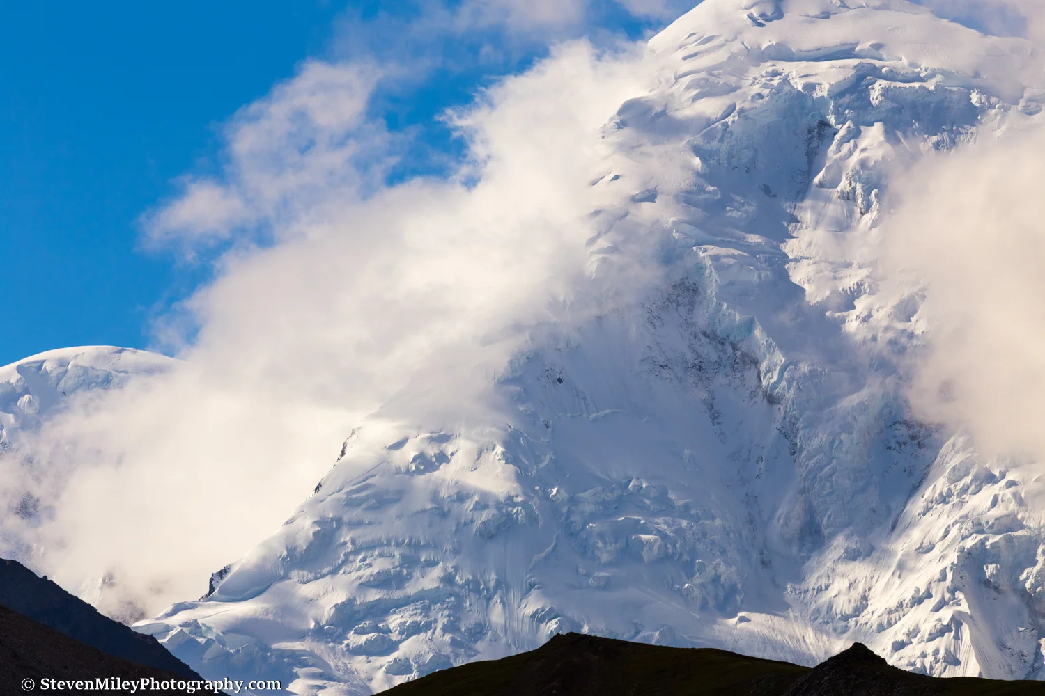
4. Pass To Wood River

_L5A3460.jpg

The highlight of my summer was hiking nearly 130 miles from Black Rapids to Healy across the eastern Alaska Range. This is my favorite shot from the trip because you can tell we’re in the middle of a rugged, off-trail backcountry expedition by studying the details and terrain without any narrative. Read about this traverse here.

5. Twenty Below Doghouse Portrait

_L5A5032.jpg

I loved how the light was catching this sled dog’s face framed by the doghouse opening on this frigid morning in Interior Alaska. The frozen dog spit helps convey how cold it was at the time, nearly twenty degrees (°F) below zero.

6. Eastern Alaska Range Sunrise

_L5A0226-2.jpg

I’ve taken many selfie shots on a timer like this one but I don’t think I’ve ever looked so awesome. I hiked up a mountain ridge overnight to catch this 3 a.m. sunrise in the eastern Alaska Range near Black Rapids, and after sunrise I hiked all the way to the ridgeline above the Jarvis Glacier canyon. Hands down my favorite day spent in the mountains last summer. Read more about this adventure here.

7. Onemile Creek Frozen Waterfall

_L5A8214.jpg

I made a couple trips to this frozen waterfall in the spring. A little scrambling will get you behind the ice, which glows like an electric blue curtain. Read about this waterfall here.

8. Pioneer Peak Sunrise With Denali

_L5A1149-HDR-2.jpg

I hiked overnight along the Pioneer Peak-Austin Helmers Trail for this sunrise shot of Pioneer Peak with Denali in the background. I mainly wanted to hike the trail, but I planned this shot in Google Earth beforehand and it came out fairly nice. It says “Palmer, Alaska” without being too obvious.

9. Hidden Alpine Lake

_L5A4883.jpg

There’s a trail on the Kenail Peninsula that doesn’t see much traffic even though it leads to beautiful views in no time. My brother and I made an excursion from the trail to visit this pristine alpine lake and another two lakes feeding it from above. We had just hiked the Reed Lakes Trail in Hatcher Pass which was flooded with people, so it was nice to have scenery like this all to ourselves.

10. Donnelly Lake Reflection

_L5A5655.jpg

I camped overnight at Donnelly Lake to shoot the aurora and wound up with relatively calm water the next morning, which made for some nice reflection shots of the Hayes Range. This wasn’t the sharpest reflection I photographed but it features my tent, which hints that this isn’t Wonder Lake or Reflection Pond in Denali National Park, though the terrain might look similar.

Click here to see my favorite images from 2017.


Black Rapids To Healy Traverse Part IV: Wood River to Healy

 
Crossing a braid of the Wood River to avoid bushwhacking.

Crossing a braid of the Wood River to avoid bushwhacking.

This is the final entry in a series covering my traverse from Black Rapids to Healy in early August 2018. Read Part I, Part II, & Part III.

After nine days of dreary weather the sky finally cleared and we had our first dry, sunny day of hiking ahead of us. We agreed to take an extended lunch later to bask in the sun’s warmth and rejuvenate our bodies. A long downhill stretch along the Wood River would bring us to our second food drop, which we were looking forward to because it held the extra food abandoned by our companions John & Mike who left the traverse early. With high water levels sure to subside and the final portion of our route following the widely traveled Healy Creek, we expected to encounter few difficulties the rest of the way.

Day 10:

_L5A3460.jpg

Thin ice covered the streams in the morning but we quickly warmed up in the sun as we scaled a steep scree slope leading to a pass overlooking Wood River. I spied a couple Dall sheep on the opposite side of the valley and the scree slope was full of sheep and caribou tracks. At the pass we could see for miles over distant peaks and valleys, and we spotted a cabin with an airstrip beside the Wood River down below. A well-trodden game trail full of bear scat led down from the pass alongside a charming mountain creek.

_L5A3574.jpg

The creek narrowed as it wound through a canyon and we were forced to cross back and forth where it pinched against cliffs. A trail bypassing the canyon through the brush above the creek could have saved us time and energy, but the creek was probably the most beautiful we saw during the traverse and I’m glad I got to see it up close. Maybe I just feel that way because it wasn’t raining. The creek intersected Wood River and we stopped to enjoy lunch in the sun while studying the nameless peaks towering over the headwaters of the river.

_L5A3652.jpg

A short distance past the cabin we found the wreckage of a crashed airplane. There have been several aviation accidents along the Wood River and I couldn’t determine which one this was. We cruised for several miles down the gravel bar in the afternoon sun, crossing and re-crossing several braids of the river to avoid hiking through the brush along the edge as much as we could.

_L5A3689.jpg

That evening we set up camp on the gravel bar and built a fire out of driftwood. It was the first time we had an enjoyable evening relaxing outside our tents since Day 2 of the traverse over a week earlier. The weather was finally warm enough and dry enough for me to wash some of my clothes in the stream next to our camp and we charged electronics using the solar panels again. A small group of caribou approached the river near sunset and were about to cross when they spotted us and darted away.

Day 11:

_L5A3690.jpg

The next day we hiked for a few miles along the gravel bar and through the brush to our second food drop at the Wood River Inn airstrip. We found our stash by lunchtime and tore into the extra food belonging to our companions John and Mike who had flown out early. (The Snickers bars were the first to go.) At this point there was no question we would reach Healy in fine shape. We looked around at the sprawling Wood River Inn compound, which was devoid of people (and horses) at the time but obviously still in use.

_L5A3721.jpg

We hiked downriver about a mile through muddy forest until we found a braided section of Wood River suitable for crossing, shown in the image above. As we hiked along the other side of the river we picked up a horse trail and practically flew to Cody Creek on it. The Cody Creek gravel bar was fairly wide but we were forced to cross the creek a few times where it pinched against steep slopes of brush. The sun made a failed attempt to break through the clouds as we set up camp, then light rain began falling after holding off most of the day. Rain didn’t matter anymore—the Alaska Range had already thrown us its worst and we would be eating cheeseburgers in Healy in another two days, dry or not.

Day 12:

_L5A3746.jpg

We continued up Cody Creek the next morning and passed a huge side valley where most of the flow seemed to be coming from. After that hiking was smooth and easy all the way to the head of the valley. We passed some tents and horses on our left before hiking up the trail to Cody Pass.

_L5A3774.jpg

As we descended from Cody Pass to Healy Creek the sun came out and the wind began gusting heavily against our backs. We encountered a pair of hunters with pack horses near a weathered, out-of-place bus similar to the famous bus on the Stampede Trail. One of the horses was ailing so they were returning early and we kept pace with them for a few miles as we continued down Healy Creek. We encountered another group of horseback hunters later and passed a pickup truck parked along the creek after several miles. The scenery was still great but the wilderness vibe was quickly fading away. Soon, we would be on the dirt road leading into Healy and the adventure would be over.

_L5A3787.jpg

With 15+ miles left to Healy we set up camp in what we thought was a sheltered spot along the gravel bar. A strong wind gust still caught hold of Peter’s tent and snapped one of the poles, but he was able to repair it. What a sad fate for the tent after having withstood so many nights of rain without leaking during the traverse. A rainbow appeared upstream as threatening rain clouds rolled over the mountains. I went to sleep anxious to reach the road the next day.

Day 13:

20180813_183732.jpg

The weather was fittingly gloomy as we hiked the remaining half-dozen or so miles to the dirt road leading past Suntrana to Healy. I didn’t take any pictures with my DSLR on the last day because I was too tired and it didn’t really feel like we were in the Alaska Range anymore. The sun came out by the time we reached asphalt and I became uncomfortably hot for the first time during the traverse. We could have easily hitched a ride from there, but we walked an extra few miles just so we could say we finished at the 49th State Brewery, where we had been planning our celebratory meal for days. When I walked inside the porch area I saw a couple I knew from Delta Junction waiting to be seated, which felt strange because I had just seen them a few days before I started the hike and the chance meeting jarringly brought me back to normal life after 13 days in the wilderness. Mike, who flew out at first food drop, met us at the restaurant along with Phillip’s girlfriend Mary (who threw McDonald’s to us on Day 8) and they drove us back to Fairbanks.

I didn’t get the chance to execute many of the shots I had planned due to bad weather during the traverse, but Mount Hayes and the rest of the eastern Alaska Range will always be there waiting.

Mount Hayes (13,832 feet), taken in August 2016 near Hayes Glacier where we passed on Day 5 of the traverse

IMG_8050.jpg