
In early August 2018 I traversed the eastern Alaska Range from Black Rapids to Healy. My companions and I used rafts for the initial Delta River crossing but we relied on our feet to carry us the remaining 120+ miles. We started with eight people, planned to finish with six, but ultimately finished with only four. Miserable weather plagued most of our trek as we crossed rugged glaciers, steep mountain passes, countless icy streams and rivers, thick brush, soggy tundra, and long valleys. I meticulously planned landscape shots of the big mountains of the Hayes Range before the trip, but not a single one came to fruition as the summits remained hidden in dreary overcast skies. At least I had the opportunity to take plenty of adventure shots.
The goal of the traverse was to scout a route for a potential trail that experienced backpackers could complete without pack rafts. Pack rafts are great, but they're expensive and not widely available, and floating on Alaska's swift glacial rivers can be scary if you don't have any experience. With this in mind, we started our traverse by following the first major unnamed drainage south of McGinnis Creek because it would be a good place to build a bridge across the Delta River and the creek quickly leads to epic views, and we finished by following Healy Creek into the town of Healy which made the route naturally reversible and very scenic from start to finish.
I certainly didn't take pictures of everything, including some rather amazing moments like a golden eagle flying right by my head, or the dozen caribou that ran past our camp in the fog while I was filtering water, or my companions and I crossing a stream containing cabin-sized chunks of ice collapsed off the side of Gillam Glacier. The captioned images included in this and upcoming posts will just have to suffice.
Day 1:
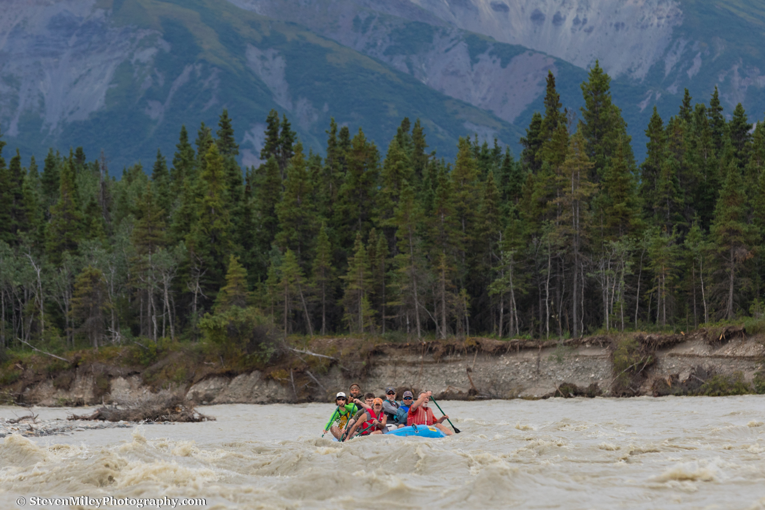
The adventure started from the very beginning. We didn't have enough pack rafts to cross the Delta River so the team rented a large raft which could ferry everybody and their gear across. I opted to cross the river in my pack raft because I didn't want to risk losing my camera gear and this way I could help rein in the big raft. We scouted the river very carefully before putting in and I followed the planned route easily, crossing to the far side of the river early on and taking out at the first available eddy. The others came around the bend in the river as I awaited with my camera, but as they grew closer I realized they were still in the middle of the river and going to sail past where I had landed. If you look at this image you can see the far edge of the river is mostly calm while the raft is heading for some rough waves which we intended to avoid. I watched my friends catch a couple of big splashes and narrowly avoid a big tree in the river as I raced along the edge to help them when they finally reached the shore. So many people (adventurers and hunters alike) have run into serious problems or have even been killed trying to cross the Delta River—don't understimate the danger.
After four or five miles of easy walking mixed with some moderate bushwhacking, intense rain began falling as we neared an unnamed glacier covered under rock debris and vegetation at the headwaters of the unnamed drainage across the Delta River. We nicknamed the drainage "Pillsbury Creek" and the glacier "Pillsbury Glacier" because they lie adjacent to Mount Pillsbury. The sun shined briefly before the rain stopped, then dense fog quickly rolled up the creek and swallowed the landscape.

After the fog set in we had to route find across "Pillsbury Glacier" with almost zero visibility, which was rather tough to do because we couldn't see the ice cliffs and other obstacles we had to circumvent until we stumbled onto them. If the conditions had been better I would have poked my head inside the big ice cave at the terminus.

After ascending a steep slope of loose rock on the far side of "Pillsbury Glacier" we began following a game trail up to a pass leading to McGinnis Glacier. As the terrain flattened out near the pass and the game trail faded out we had to consult our GPS reading several times to stay on the right course. We eventually found a small lake near the pass and set up our first camp, unable to see any of the scenery around us. The first day was a wake-up call to a few team members that the hike would be tougher than they thought.
Day 2:

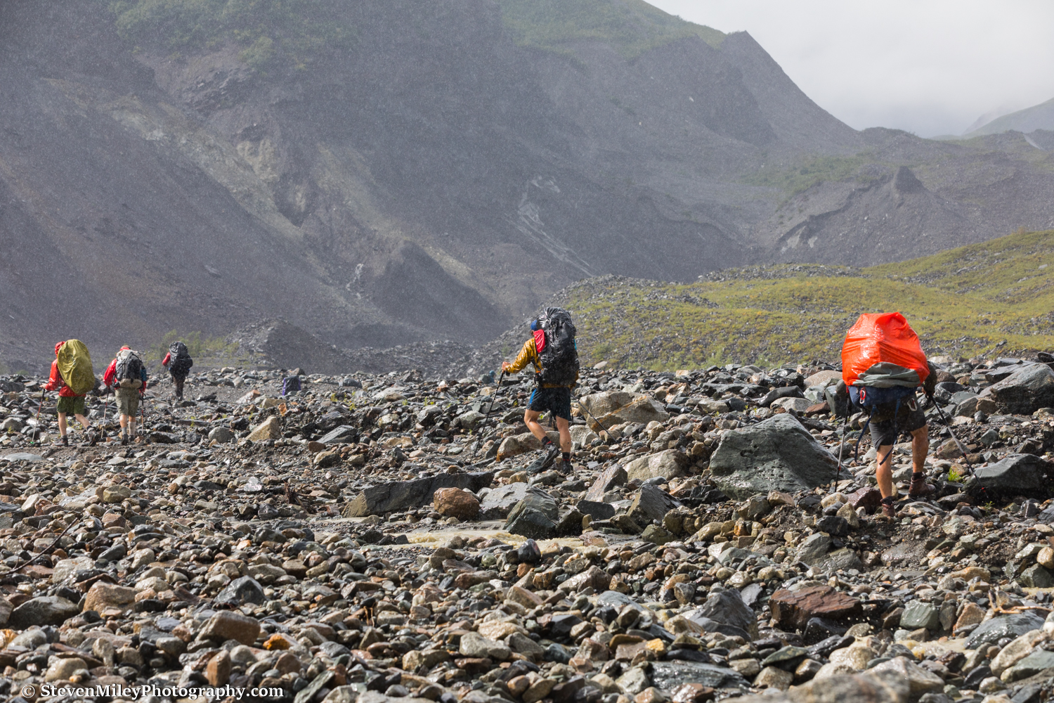
The fog eventually lifted the next morning and we descended from the pass to McGinnis Glacier below. Crossing all the streams emptying from the glacier didn't appear practical so we opted to cross the rocky moraine.

There was one rowdy stream flowing between the two branches of McGinnis Glacier we had to cross. We found a spot where it leveled out where the crossing wasn't that bad. If we had crossed the glacier moraine starting higher up we could have avoided some dead-end ice cliffs and we might have been able to avoid this stream crossing altogether.

After the stream crossing we took a less-than-optimal route over the second branch of McGinnis Glacier. Some members of the group didn't have much experience hiking over glacier moraines so they felt uncomfortable picking their way through the rubble. After making slow progress we decided to climb off the moraine and bushwhack along the edge where everyone would feel safe, but the last bit of hiking on the glacier turned out to be the most difficult and dangerous. It turned out there was a nice game trail on the edge of the glacier and the terrain quickly changed to open tundra after we gained a little elevation. We could have also cut directly to a prominent hump in the moraine leading to the far side.

The light wasn't great but we at least got to see McGinnis Peak (center) from bottom to top later in the day. The cool thing about our chosen route was how close it brought us to some of the big mountains of the Hayes Range and how quickly we made it there. We also caught a couple short glimpses of Mt. Moffit through the clouds to the right of the 10,000+ foot peak on the right. I’ve visited this area once before and it’s an amazing place to catch a sunrise.
Day 3:

Packing up in the mornings was a slow process with a big group. In this shot we are about to leave our camp near McGinnis Peak and circle around to Trident Glacier. The cloud ceiling was already lowering and soon we were enveloped in fog again as we climbed above 6000 feet elevation. We relied on GPS to help navigate until we dropped below the cloud ceiling again as we followed a drainage down to the glacier. In the fog we stumbled on a piece of unexploded ordnance inexplicably lying some 30 miles from the military's impact area to the north; what a shame that with all the possible ways I could die in the wilderness I have to add being blown up to the list.

When we reached Trident Glacier steady rain was falling and we could only see the bottom half (or maybe third) of 13,000+ foot Mt. Moffit, though we stood less than a mile from its base. Dall sheep were mulling around its lower flanks. An eye-catching icefall separated the heavily glaciated backside of McGinnis Peak from Mt. Moffit. Even with the mountains mostly hidden everyone still felt awed by the scale of the rock and ice visible to us.

Another shot of the northwestern flank of McGinnis Peak and the dramatic icefall at its base. We could have saved some mileage by cutting north and bypassing this area but the closeup views were worth it. I can only imagine how awesome it would be to see the entirety of Mt. Moffit looming overhead from this spot; it would be an iconic view that would attract people from all over the world if there were a trail leading to it. We paralleled the glacier for several miles following game trails as best we could until we found a good crossing point where we set up camp.
