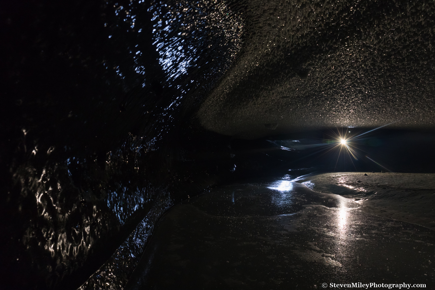
Ice version of the Rolling Stones logo?
Tazlina Glacier is one of the largest glaciers in the Chugach Mountains and all of Alaska by land area covered, but if you search online you won’t find more than a handful of non-aerial images of the glacier. The wide face of the glacier calves into a pro-glacial lake (which I’ll refer to as “Tazlina Glacier Lake”) connected via a 1-mile long outlet to the vast Tazlina Lake. Huge icebergs drift around Tazlina Glacier Lake in the summer and become trapped in the lake ice during winter. I first became aware of the glacier while scrolling across Alaska in Google Earth, and it beckoned to me every time I caught a brief glimpse of it from over 20 miles away along the Glenn Highway for over a decade. I originally thought I would visit the glacier with my pack raft in the summer, but hiking in from the road would probably be the most boring slog I’ve ever done. Visiting the glacier in winter hadn’t occurred to me until last spring when I realized conditions would be perfect for navigating the lake without concern for an iceberg rollover or major calving event flipping my raft.
A perfect weather window materialized for an overnight trip to Tazlina Glacier during a few days I had set aside near the end of my busy tour guiding season in mid-April. The aurora forecast also looked promising, so I contacted Meekin’s Air Service to arrange a fly-in trip via Super Cub. My friends Phillip Wilson and Mary Webb came along, shouldering camp gear and serving as models.
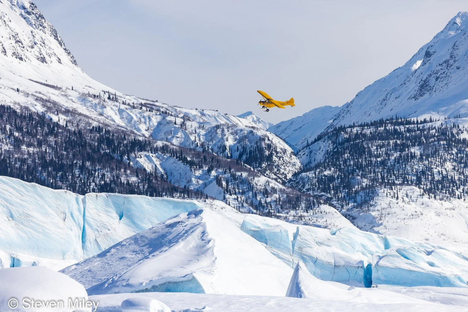
The pilot executing a flyby over the glacier after the last dropoff.
We flew into the head of Tazlina Lake one-at-a-time in the Super Cub. I landed first and snowshoed just shy of four miles to the glacier terminus where serrated blue towers of ice loomed above the glacier lake. Mary and Phillip would take 2 or 3 hours to catch up, so I dropped most of my gear near a tall iceberg and went scouting with my camera.

Near the face of the glacier lie chunks of toppled ice and larger icebergs recently calved off the glacier. The movement of the glacier and presumably a few large calving events throughout the winter have broken and pushed up the lake ice in an obvious curve several hundred feet in front of the glacier face.
The glacier appeared motionless and stable, but the numerous chunks of ice scattered in front of its face had clearly toppled off the glacier throughout the winter, and the lake ice had also been forced upward by the movement of the glacier along a contour a few hundred feet in front of the face. Melt from the afternoon sun pooled up along this curve and around the bases of the icebergs, and only in these spots could I see the ice of the lake, which was otherwise covered in windblown snow. Earlier in the winter the lake would be mostly or totally clear of snow, similar to the Black Rapids Glacier pro-glacial lake that I visit frequently, and I suspect some years it’s mostly clear later in winter given the right weather. Experiencing prime skating conditions on the lake would be amazing.

Tazlina Glacier.
After photographing around the face of the glacier, I found three impressive ice caves in three separate massive icebergs within a few minutes’ walk of each other. All three ice caves contained incredibly blue ice, and two of them glowed partially. A huge shelf of ice had collapsed off the ceiling in one of the caves, and atop this shelf the entire cave glowed a deep, mesmerizing blue color. There was no debris to see in the ice, no cracks, and no gradation in the color—just a featureless, disorienting navy blue glow permeating the whole chamber like a black light illuminating an empty white room.
One of the other ice caves formed a curving tunnel from the top of the iceberg to the bottom. The bottom entrance was quite photogenic and I took my favorite photo of the trip there.

One of several ice caves found in some of the larger icebergs in Tazlina Glacier Lake.
I found the remaining ice cave after climbing atop a very large iceberg to scan the area nearby. Surprisingly, there was a large cave opening on top of the iceberg leading down a steep incline into a glowing chamber at the bottom.
After climbing atop another nearby iceberg, I spotted Phillip skiing across the lake toward the rendezvous spot. I returned there to find Mary already waiting where I left my gear, resting after arriving 15 or 20 minutes earlier. Phillip skied in with a large backpack on his back and another large bag slung over his chest and stomach, and Mary brought her own pack, too. I’m not sure why they brought so much junk for an overnight trip, but I guess it was good exercise.

Tall iceberg and campsite. Would have been awesome to catch some aurora from this spot.
We ate dinner as golden hour set in, then set off to explore the ice caves. Sunset wasn’t particularly impressive that evening since the mountains to the west obstructed most of the late evening sun in the glacier valley. We returned to camp under twilight and settled into our sleeping bags as darkness set in, sans tent. I spent a couple hours disappointedly watching solar wind measurements as they indicated the expected great aurora show that night would not be happening, then fell asleep. Oh well, maybe next time.

Mary skies in front of an ice cave at sunset.
The next morning I rose before my companions and walked about a mile to investigate the icebergs at the other end of Tazlina Glacier Lake. The frost on my sleeping bag and the chill on my cheeks told me it was about 0°F (-18°C) or a few degrees above. For some reason, I didn’t feel like bringing my camera, even though the golden sunrise light beaming off the snow around the icebergs was as good as it gets for a landscape photographer. I passed some impressively large icebergs with cracks to explore, and I spotted another iceberg about a half-mile farther away which appeared to have a huge cave opening.
My companions awoke when I returned just as the sun began shining on our campsite. The April sun quickly brought the temperature up as we ate breakfast and let our sleeping bags defrost. After packing up we set out to explore more icebergs and we were soon stripping layers and unzipping jackets to cool down.

Skiing beside a massive iceberg in Tazlina Glacier Lake.

Navigating a giant crack in a large iceberg.
Some of the icebergs near the outlet of the lake were absolutely gigantic. One of them contained a maze of intersecting cracks through which we could pass from one side of the iceberg to the other, albeit with a bit of scrambling and body contortion required. I wouldn’t go anywhere near an iceberg like that in summer season in a raft or kayak because, as big as the iceberg looks, only 10% of it sticks out above water, and I’ve seen big icebergs like this flip in Bear Glacier Lagoon before.
After we played around this neighborhood of large icebergs and photographed for a bit, Phillip pulled out his drone while I continued across the lake toward what I thought was a giant ice cave opening in the last large iceberg before the lake outlet. However, when I neared the iceberg I realized the opening I saw from a distance was actually just one side of a very short tunnel through the ice. Phillip’s drone caught up to me and he flew it in and out of the tunnel a couple times while I set my water bottle up to collect water dripping from an icicle hanging from the opening. I circled around to the other side of the tunnel and found it framed the mountains quite nicely from that side, but I couldn’t help thinking the ice resembled the tongue & lips of the Rolling Stones logo. (See first photo in this post.)
Phillip and Mary joined me at the iceberg where we broke for lunch before we started our trek back to the landing site. Rather than take a direct route back to our trail, which passed through some very deep and unsupportive snow much of the way, we followed the firmer drifted snow on the edge of Tazlina Lake. I barely sank at all in my snowshoes as we rounded the lake, but I couldn’t glide across the snow like Mary and Phillip, who quickly pulled ahead of me. We paralleled a set of wolf tracks for awhile until we neared our old trail, where we began sinking in the snow again. I started to gain on Mary and Phillip again as they slowed down over the final stretch, but they still beat me to the landing site just as our plane arrived.
On my flight back to the airstrip the visibility was so good I spotted Mount Hayes and the other tall mountains of the eastern Alaska Range well over 100 miles away. The pilot pointed out bear tracks in the snow high on the mountains in places where I would only expect to see Dall sheep traversing due to the exposure. When I landed I felt the overnight trip had been much too short and I should have spent at least 2 or 3 nights photographing around Tazlina Glacier Lake, but now it seems much simpler to get there so I’m sure I’ll return soon, hopefully when the ice on the lake is free of snow and the aurora is dancing.

Dinnertime at our glacier camp.